Here Be Dragons: Google Earth As Omniscient Atlas
Daily Serving
February 7, 2012
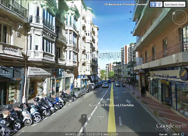
Boulevard Princesse Charlotte, Monte Carlo, Monaco. Screen capture using Google Earth.
When I was a child, I spent countless hours poring over a Cold War–era National Geographic photo atlas. I traced every road and river, in every country, some which no longer existed or were currently in the process of brutal disintegration (à la balkanization). Sometimes, when I was really lucky, a country would be represented by two or three photographs. Some countries earned no photographic representation. Nonetheless, these photographs helped me learn that Thai women had really long fingernails, Brazilian men wrestled anacondas naked, and Africa was an untamed land bereft civilization and modernity. This photo atlas provided a seven-year-old me with irrefutable evidence about my world, but it also left so many questions. Malawi and Kyrgyzstan had no photos; what were they like? As I grew older these questions became more nuanced: Are all Algerians really Tuaregs? Might South Americans actually wear clothes? Are Western Europe and the United States as idyllic and perfect as the amber waves of grain imply? As much of a colonial travesty as that book was, it sparked an intense interest in the world and provided me with enough information to later deconstruct its own narrative.
Jump forward a few decades. Croatia is firmly established as a tourist hotspot, Dubai is megalopolis, and Burma is now Myanmar. So much has changed. We also now have a qualitatively different kind of atlas: Google Earth. This new atlas—a seven-year-old technology that allows me access to every nook and cranny of the planet’s surface—ostensibly offers a potential antidote to the inaccuracies of older atlases. This computer software exposes the mysteries of the world; every single village, building, and street on the planet is immediately viewable to me, save those hidden beneath thick canopies.
Prior to photography, atlases were geometric abstractions, lines representing places that were theoretically real, but unconfirmed to those people who had never been to them. The dragons and mythical creatures that sometimes populated these maps speak to their susceptibility to distortion and myth making. But with the advent of photography, people believed they could see the unmediated reality of these places. Photography offered a form of documentation that then (and now) carried more authority than technical illustrations. A “higher” form of knowledge was now available. But as my childhood photo atlas shows in hindsight, nominal and highly selective representation does little to demystify those places we’ve never been, and this epistemic pitfall can be found in Google Earth as well.
On the surface, Google Earth is far from a medieval abstraction aided by a few self-fulfilling photographs. When I look at the Congo, I see it exactly as it was at a distance of 2,300 feet on Tuesday June 29, 2010. Google Earth also contains millions of geotagged photos. Provided primarily by tourists and amateur photographers, these images offer much more than a bird’s eye view of a particular locale. In many parts of the world, Street View offers an even more in-depth view. While planning a potentially hypothetical trip to Monaco, I traveled around the streets of Monte Carlo noting where restaurants and adequate parking are (note: there is a lot of one, and very little of the other). By having an on the ground look, I will know that town inside out before I even land in Nice.
Does this deluge of specific, visual information foster only an armchair interest in the world? Why even go to Monaco? I’ve seen it. So what is left of the experience? I can visit San Diego if I want warmth, visit Vegas if I want wealth, and visit Napa if I want wine. Does our easy access to so much information about the places viewed render them “known” and negate our search for a deeper understanding of a place or a visit to it? However, my desire to visit Monaco—or Saint Helena, or Iceland, or the Mongolian steppes—is not diminished one bit. That intense yearning to learn more about these places and really see them (whatever that means) still persists. This suggests two things: that there is something more to the places we visit than what we see, and that there is something lacking in the apparent omniscience of the digital atlas.
There is really no easy way for someone in Monte Carlo to document her experiences of taste, touch, and smell. Sight and hearing, on the other hand, are easier senses to capture; images and sounds less complicated to disseminate. It is easy then to equate places with their sights, those buildings, monuments, and natural wonders that are named for the sense that we most associate with them. And until virtual reality and holograms are perfected, the first-hand experience of a distant place is absolutely unattainable. So while I am zipping down the rues and avenues with Street View, I am missing out on the sounds of the horns and seagulls, the mild Mediterranean breeze, the coconut scent of the artificially buxom and bronzed starlets, and the taste of the latte that tops it all off. More importantly, I am missing out on the first-hand experience of all it all. I engage in no conversations with locals, no arguments with merchants, and no drinks with fellow tourists. That is, all that I enjoy about visiting a place is completely missing. Even sightseeing, the most Flickrable activity imaginable, is nothing without the phenomenological experience of feeling the mass or the emptiness of a building in the pit of your stomach.
Yet we use Google Earth as much more than a surrogate for tourism. It is a compendium of knowledge about the world—knowledge that may provide the basis of how we think about the world. Popular, specious knowledge says that to see is to believe and that a picture is worth a thousand words. By my count then, Google Earth is worth untold billions of words, constituting many, many beliefs. Given the scientific satellite imagery and seemingly exhaustive photo documentation provided, viewers may erroneous take these “beliefs” to be objective approximations of the world when sometimes they are incredible aberrations.
For example, North Korea is a starving nation. It has been reported that in 2011, authorities reduced the daily caloric intake for each individual to 700, or one Venti Double Chocolaty Chip Frappuccino from Starbucks. The average official salary for workers is $2 per month. The country is wracked by poverty and oppression, but Google Earth provides scant acknowledgement of this. To the uninformed, the geotagged photos of Pyongyang provide evidence of a wealthy nation. Magnificent architectural achievements abound, great stadiums suggest that the city may have once been host to the Olympics, and nary a starving child is to be found. Ever the skilled curators, the North Korean government finely crafts how the rest of the world sees it. They disseminate few images from their country and those few outsiders who are allowed in are taken on highly orchestrated and monitored tours that show them only what the officials want to be seen. In turn, these visitors can only rarely (and very illegally) document those starving and dying in the streets.
But even outside dystopian societies, Google Earth remains a world of selective documentation. Take, for example, the city I was born in. It has a population of over 300,000. It has shopping malls and theaters, rich and poor neighborhoods, hospitals and offices. Some of this is made visible by Google Earth, but very little. The reality of this city is almost entirely obfuscated by an eighty-five acre lysergic Zion: Disneyland. To Google Earth, outside of Disneyland, Anaheim and its hundreds of thousands of residents do not even exist. This phenomenon can be found, to varying degrees, in every city in the world.
The fact is, most of us simply do not photograph liquor stores and gas stations. We photograph that which we find interesting and that which we think others will find interesting. This leaves us with a digital photo atlas of the world that is entirely unreal. The slums of Anaheim are not photo worthy, nor are the well-kept buildings of Freetown, Sierra Leone. All regions of the world are affixed with preexisting narratives, and tourists, journalists, and Google users often reinforce these narratives through the photographs they shoot and share.
But let us not forget the lesson of my childhood atlas. While it promoted a racist and NATO-centric view of the world, it nonetheless gave me knowledge for critiquing that very viewpoint. I must first know that Freetown exists before I can even imagine challenging how it is represented to the world. After witnessing countless photos of shanties and dilapidated buildings in Freetown on Google Earth, I eventually came across a photo of a sleek, Mies van der Rohe–inspired bank building—a stark contrast to the narrative of a rural and bush sub-Saharan Africa. But then again, thank God for the photos of the shanties; it would be a tragedy to forget them.